The Long Story Behind a Strait’s Name
Strait names can preserve language, navigation, and mapmaking choices; learn how to read them without mistaking one label for a place’s full history.
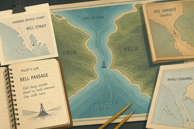
A chart on a harbor office wall calls the narrow water between two coasts the Bell Strait. An older pilot’s notebook calls it the Bell Passage; a school atlas uses a local-language name that sounds different from both. Strait names often arrive this way: as labels inherited from different speakers, sailors, and mapmakers, each with a particular reason for naming the water. Reading those names carefully reveals how a route became legible to outsiders without pretending that a single label tells its whole story.
One passage, several names
Imagine a clearly hypothetical place: a sheltered channel between the fictional islands of Orin and Vela, connecting an open gulf to a busier inland sea. Local fishers call it Naru, a word in their language associated with a turning current. A coastal pilot’s log calls it Bell Passage after a bell buoy used to mark a hazardous shoal. A later map labels it Bell Strait, while a neighboring state’s chart prints Naru Channel.
None of these labels needs to be a simple mistake. Each may refer to the same water while emphasizing a different feature: a local name, a navigational aid, a conventional type of passage, or an administrative preference. Even the word “strait” is a classification rather than a complete description. It says that the water is narrow relative to the land around it, but it does not explain who has traveled there, what the channel connects, or how its name changed.
For a reader, the first useful move is to treat the names as clues to the people and purposes behind the maps, not as competing claims that can be settled by choosing the newest-looking label.
Strait names and language
Place-names can carry sounds, meanings, and grammar from the languages spoken along a coast. A name may describe a current, a landmark, a direction, or a community associated with the shore. When another language adopts it, the spelling can shift to fit unfamiliar sounds or a different writing system. A map may preserve that adapted form long after local usage has changed—or may prefer a newer spelling used by local authorities.
Translation adds another layer. A word for “narrow water” might be rendered as “strait” in one map tradition and “channel” in another. Those English terms overlap in ordinary use, but mapping conventions may apply them differently. In some contexts, “passage” stresses a route through or between obstacles, while “sound” can name a broad waterway with its own regional history. None of these words alone proves that two labels refer to different bodies of water.
To compare names, look for more than a word-for-word translation. Note the script, spelling, language, and source date if provided. A gazetteer or place-name authority may explain a preferred form, while a chart legend can clarify how its publisher uses terms such as strait, channel, and passage.
Routes shape the label
A name can become prominent because it is useful to people moving through the water. Sailors need to distinguish an entrance, a channel, a shoal, and a safe approach. A buoy, lighthouse, headland, or harbor may supply a memorable reference point, and a logbook can turn that practical shorthand into a repeated label. If later charts copy the wording, the phrase can outlast the navigational feature that first made it useful.
In the imagined Orin–Vela case, Bell Passage begins as a pilot’s working term tied to a bell buoy. A chartmaker later calls the whole narrow route Bell Strait. That change might reflect a broader geographic convention, not a decision that the buoy named every part of the water. Meanwhile, Naru remains familiar to people who describe the current and the surrounding coast in local terms.
Route names also travel unevenly. A label used by commercial pilots may spread across charts designed for distant readers, while a name common on shore stays within local speech or appears only on regional maps. The map that circulates most widely can make its preferred name seem inevitable, even when it represents only one strand of use.
Why do maps use different names?
Can one strait have more than one name?
Yes. Different communities, languages, chart publishers, and government authorities may use distinct names for the same passage. Check whether each label points to the same stretch of water before treating the difference as a disagreement about geography.
Does “strait” mean the same thing as “channel”?
The terms can overlap, but usage varies by region and map convention. A chart’s legend, place-name index, or explanatory notes can show how its publisher distinguishes them.
Why might an older name remain on a chart?
Charts and atlases may preserve established labels for continuity, or may draw on sources that have not adopted a newer form. The name’s appearance is evidence of that map’s convention, not by itself a complete account of current local usage.
How can I check which name is preferred?
Compare a current local authority’s place-name information with nautical charts and regional gazetteers. Record the source and context for each form rather than assuming that one source speaks for every community.
Map conventions leave traces
A map is a selective account. Its scale determines how much coastline can be shown, its purpose affects which features receive labels, and its naming rules shape how those labels appear. A small regional map may use a local name because it serves residents; an ocean chart may favor a familiar navigational term that helps mariners identify a route quickly. A border agency or national mapping office may adopt a standardized form for official records.
Standardization helps maps and documents refer consistently to places, but it can flatten a layered naming history. One approved label may be needed for a database or chart series even when several names remain meaningful in speech. That practical choice does not erase the other forms, and it does not settle every question about their origins.
When comparing maps, notice whether a name is printed as the main label, shown in parentheses, translated, or omitted. Those choices can indicate which naming convention the map privileges. They do not necessarily tell you why that preference was adopted; for that, look for an accompanying gazetteer, official naming record, or note from the publisher.
Tracing the invented case
Say you are preparing a small classroom map of Orin and Vela. You find Naru on a local-language map, Bell Passage in an old pilot’s notebook, Bell Strait in a general atlas, and Naru Channel on a neighboring state’s chart. Rather than choosing whichever label looks most familiar, you compare the mapped locations, identify each source’s audience, and check whether the names refer to the same water.
You then notice that the notebook’s Bell Passage label sits beside a bell buoy, while the atlas places Bell Strait over the full narrow connection between the gulf and inland sea. The local map uses Naru for that connection and nearby current. The state chart’s Naru Channel may be a translation or a naming convention; without a note explaining it, you leave that relationship open rather than inventing an origin.
Your finished map could use the locally preferred name as its main label, if an authoritative local source supports that choice, and include the other forms in a short note with their sources. If the map’s purpose is navigation, the relevant chart’s naming conventions may matter more. Either way, the observable result is a map that tells readers what name it uses and preserves enough context to connect the other labels.
This invented case offers a useful discipline: establish that names refer to the same water, then ask who used each form and for what purpose. Similar spellings do not prove a shared origin, and a navigational label does not automatically explain a local name.
What one name cannot tell you
A strait’s label rarely contains its entire history. It may not reveal which communities first used the name, whether a translated form preserves the original meaning, or how travel and political administration shaped later choices. Those questions call for evidence beyond the label itself: local place-name records, older charts, language guidance, and accounts of how a route is used.
Even a well-documented preferred name is not a substitute for the other names people use. The point is not to treat every form as equally official in every setting, but to distinguish official convention from linguistic history and everyday use. A nautical chart can be the right source for chart terminology while a local authority is the better source for a community’s preferred place-name.
When a strait carries several labels, keep the source attached to each one. That small habit makes the map easier to read and leaves room for a place’s history to remain larger than any single name.