Scale Bar or Grid Lines: Two Different Jobs on a Map
Scale bar or grid lines: learn which map feature estimates a route’s distance and which identifies a position, so you can read the map with confidence.
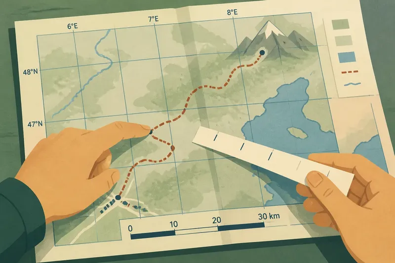
You are tracing a road across a folded map when someone asks how far it is to the next town. A finger follows the route, but the map’s grid squares seem easier to count. That is the moment to separate two tools with different jobs: a scale bar helps estimate distance, while grid lines help identify position. Knowing which question you are asking makes both easier to use.
Start with the question
Before measuring or reading coordinates, decide what you need to learn. “How far is it from here to there?” calls for the scale bar. “Where is this place on the map?” calls for grid lines or a coordinate system. The tools can appear together, but neither substitutes for the other.
A scale bar is a drawn line divided into sections and labelled with real-world distance units, such as miles or kilometres. It translates a length on the page into an approximate ground distance. Grid lines are reference lines arranged across the map. Depending on the map, they may mark latitude and longitude or another coordinate system, and they help describe a location.
Keep the distinction in mind: distance describes separation; coordinates describe position.
Find the map’s references
Look near the map’s edges, in its margin, or beside the legend. Find the scale bar and note its units. A bar labelled in kilometres does not give an answer in miles unless you convert units; avoid mixing them in the same estimate.
Then inspect the grid. Lines of latitude run east to west, while lines of longitude run from pole to pole. On a regional map, coordinate lines may curve or appear at an angle because the Earth’s curved surface has been represented on a flat page. Some maps instead use a projected grid with coordinates suited to that map’s area. Read the labels and legend rather than assuming every grid is latitude and longitude.
If the map has no visible grid, it may still have a scale bar. If it has a grid but no scale bar, you can still locate places, though estimating distance requires another suitable reference. Do not treat the spacing between grid lines as a distance scale unless the map identifies it as one.
Estimate a route’s distance
For a straight-line estimate, compare the gap between two places with the scale bar. A ruler can help, but a strip of paper works well too: mark the endpoints, then compare that marked length with the bar. If the distance is longer than the bar, compare it in sections or move the paper along the bar to build up an estimate.
A road, river, or trail usually bends, so a straight line between its endpoints understates the route length. To estimate a winding route, place a paper edge along a short section, mark each change in direction, and reposition it as the route turns. Compare the accumulated paper length with the scale bar. A ruler can also work if you measure the route in short segments and add them.
Say you are looking at an invented map where the scale bar represents ten kilometres. You mark a curving footpath in several short paper-edge segments, then compare their combined length with the bar. If the marked route is about twice as long as the bar, you can describe it as roughly twenty kilometres on that map, not as an exact travel distance.
This estimate describes mapped distance, not necessarily travel time. A steep trail, a restricted road, or a ferry connection can make a short route take longer than a longer, easier one. For distance, trace the route; for journey planning, check the route conditions separately.
Locate a position with grid lines
To identify a place, first read the coordinate labels along the map’s edges. Find the grid line nearest the point, then follow the map’s coordinate convention to report its position. With latitude and longitude, latitude indicates north–south position and longitude indicates east–west position. A more detailed coordinate system may use numbers in a different order, so follow the map’s legend or coordinate key.
For a rough location, identify the grid square containing the point and describe its relation to nearby labelled places. For a precise coordinate, the map must provide enough detail to support that precision; a small printed map cannot justify an overly exact reading. If the location lies between grid lines, estimate only as finely as the map allows.
Grid spacing is not automatically uniform in ground distance. Latitude lines are not a universal ruler for east–west travel, and map projections can alter how distances and directions appear. Use the grid to locate, not to measure an unlabelled route.
Read the scale bar or grid lines?
Which tool tells me how far two places are?
Use the scale bar to estimate the map distance between them. For a route that bends, trace its shape in sections instead of measuring only the straight gap between its endpoints.
Can I use grid squares to measure distance?
Only if the map’s legend explicitly gives the grid spacing a distance value and the map’s coordinate system supports that interpretation. Otherwise, use the grid to locate a point and the scale bar to estimate distance.
Why does my digital map scale bar change?
Many digital maps redraw the scale bar as you zoom or move to a different area, because the relationship between screen distance and ground distance has changed. Use the bar displayed at the same zoom and location as the route you are measuring.
Can a scale bar give an exact journey length?
No: it supports an estimate based on the map’s representation and how carefully you trace the route. Turns, generalised map features, and travel conditions can all make the actual journey different.
Choose the right tool
When both features are present, use them in sequence without confusing their roles. Use grid lines to identify or communicate the location of a start, destination, or landmark. Then use the scale bar to estimate the distance between those points, tracing a real route if the question concerns a road or trail rather than straight-line separation.
For example, a reader locating a mountain pass can use the grid to describe where it sits relative to a nearby town. If the next question is how far a road travels from the town to the pass, the scale bar answers that separate question. The coordinate reading does not supply route length, and the distance estimate does not identify the pass on its own.
On a printed map, folds, page resizing, or photocopying can change the relationship between the printed bar and the map image. A graphic scale bar is generally more useful than a written representative fraction when a map has been resized, because the bar changes with the image. On a digital map, make sure the bar is visible for the current view before comparing screen lengths.
Map symbols, coordinate formats, and permitted routes can depend on the map’s publisher and local conditions; use its legend and current route information where those details matter.
Keep the distinction handy
When you next unfold a map, ask whether you need a position or a distance. Grid lines provide a shared way to say where a place is; the scale bar turns a measured map length into an approximate ground distance. For a route, trace its bends; for a location, read its coordinates. That simple separation makes the map easier to use and keeps an estimate from masquerading as an address.