The Border-on-a-River Shortcut That Misleads Map Readers
A border-on-a-river map can imply a neat centerline that is not legally defined. Learn how to read its symbols and choose a better source for the exact boundary.
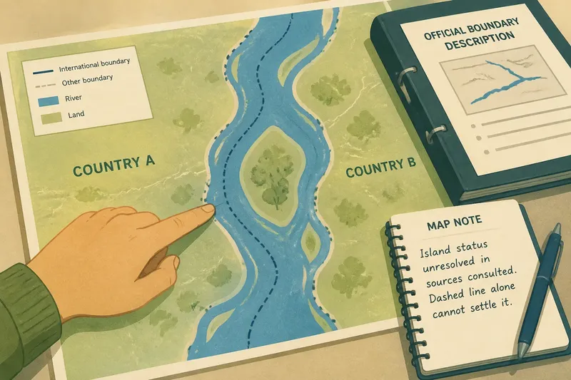
You trace a border-on-a-river map with a fingertip, following the blue channel as it bends between two countries. The line seems obvious: the river is the boundary, so its center must be the border. That shortcut can mislead. A map may show a river and a boundary close together without specifying that the boundary follows the river’s center—or even the same channel throughout.
The useful question is not simply where the blue line runs, but what kind of claim the map makes. A general reference map, an administrative map, and a legal boundary description serve different purposes. Reading them as if they all resolve the same detail can turn a convenient symbol into a false certainty.
Start with the map’s purpose
For a broad geography question—such as which countries meet along a river—a small-scale map is often enough. Its symbols help you see the regional relationship. At that scale, a thin boundary line and a blue river stroke may overlap, even if the actual boundary follows a bank, a channel, or a separately surveyed course.
For a more exact question, such as which jurisdiction includes an island or a strip of land beside the water, the general map is only a starting point. Look for a larger-scale official map, a boundary commission’s material, or the text of the relevant agreement. If those sources are unavailable, treat the precise course as unresolved rather than inferring it from the drawing.
Use a general map to locate the border; use a boundary-specific source to interpret its course.
Read symbols separately
Map design compresses information. A river may be drawn as a colored band, while a boundary appears as a fine dashed or solid stroke. On a screen, the boundary symbol may sit directly over the river for clarity. That visual overlap does not tell you whether the legal line follows the river’s midpoint, one bank, a named channel, or another defined feature.
Check the legend first. It may distinguish an international boundary from a provincial line, a disputed boundary, or a boundary whose position is approximate. Then inspect the map’s scale and source notes. A generalized map can smooth bends, omit small islands, and shift lines slightly so they remain visible. Such choices help the map communicate; they are not a substitute for boundary language.
Keep the symbols distinct in your reading, even when the printed lines merge.
Let wording guide the next move
If a boundary description says that the line follows a particular river, that phrase still leaves questions open. Does it identify the main channel, a named branch, a bank, or a centerline? Does it refer to the river as it existed when the boundary was agreed, or to a later mapped course? The surrounding wording and the agreement’s definitions matter.
Descriptions may also use terms such as “midstream” or “thalweg.” These are not interchangeable with the casual idea of a river’s visual center. A channel may have bends, islands, and multiple threads; the deepest navigable channel, where relevant, can lie away from the geometric middle. Do not assign a technical meaning from a map alone. For any decision with legal or administrative consequences, consult the authoritative boundary text and a qualified professional; applicable rules and the source’s definitions control.
Choose by your situation
- Regional overview: Check whether a reputable general map clearly shows the countries and river together; if it does, use it to describe their broad relationship, and if it does not, find a clearer regional map.
- Comparing map layers: Check whether the river and boundary layers share a source and scale; if they do, compare their alignment cautiously, and if they do not, treat any offset as potentially caused by differing generalization and seek a matched source.
- Locating an island or bank: Check whether an official, larger-scale boundary map and its notes identify the feature; if they do, follow that depiction, and if they do not, leave ownership unresolved rather than infer it from the line’s appearance.
- Reading a treaty or boundary description: Check for named channels, defined terms, and referenced maps; if the text identifies them, use those features to guide interpretation, and if it does not, consult the full boundary instrument or an appropriate professional.
- Assessing a disputed or changing course: Check whether the source distinguishes physical geography from the parties’ claims and official boundary depiction; if it does, describe each separately, and if it does not, find a source that makes the distinction or label the uncertainty.
- Checking a map’s authority: Check its publisher, source notes, and stated purpose; if these establish that it is an official boundary source suited to your question, use it for that purpose, and if not, treat it as orientation and look for a more authoritative record.
Say you are tracing an invented border on a classroom map, and the dashed line sits over a river that divides around a small island. You check the legend and find that the map is for general orientation, then consult an official boundary description that names a channel but does not state “the center of the river.” The description leaves the island’s status unclear. Your resulting map note should say that its status is unresolved in the sources consulted; the dashed line alone cannot settle it.
Questions about river borders
Does a border on a river usually follow its center?
There is no safe universal assumption. The line may be defined by a channel, a bank, a midpoint, or another rule, and the map’s appearance alone may not disclose which one applies.
What does “midstream” mean on a boundary map?
Its meaning depends on the controlling description and the feature being identified. Read the definition and nearby terms rather than treating “midstream” as a synonym for the visible middle of the water.
Why do the river and boundary lines not match?
The map may use different sources or scales, simplify the river’s bends, or offset one symbol to keep both visible. A mismatch on the page does not by itself establish that the boundary has moved.
Which source should settle an exact boundary question?
Start with an authoritative boundary instrument or official boundary map for the place and question involved. A general atlas is useful for orientation, but it may not carry the detail or legal status needed to settle a precise claim.
Keep the claim modest
A river can make a border easy to recognize while leaving its exact course difficult to read. State what your source actually shows: that the boundary meets the river, follows a named channel, or appears alongside the water at the map’s scale. The border-on-a-river shortcut becomes less tempting once you separate the symbol from the description. Before making a precise claim, check whether the source names the feature the boundary follows; if it does not, say so plainly.